Lanzarote on foot — two weeks on the volcanic island
Two winter weeks on Lanzarote: from the lava fields of Timanfaya and the Famara cliffs to the neighbouring island of La Graciosa — around 150 kilometres on foot over volcanoes, coast and lava.
Two weeks on Lanzarote — on foot across the island of fire
Lanzarote in January and February: mild winter weather, almost no rain, and a landscape that looks like another planet. For two weeks we explored the island on foot — from the lava fields of Timanfaya and the rugged Famara cliffs across to the car-free neighbouring island of La Graciosa.
This report gathers the walks of the trip: from an easy coastal stroll to pathless, sure-footed volcanic terrain (T2), including the almost 23 kilometres from Charco Verde to Piedra Marcial. Where it gets tricky — closed sections, rough access roads, route-finding in open country — it is noted with the individual tour. Between the walks we visited César Manrique's art sites — the Casa-Museo, the Mirador del Río viewpoint and the Monumento al Campesino — and stopped at the surf bay of La Santa; here, though, the focus is on the paths. In total it added up to around 150 kilometres and 2,700 metres of climbing, spread across the whole island.
The walks
Caldera Blanca loop
Across the lava field towards Caldera Blanca — the big, pale volcanic cone in the west of the island.
Black lava boulders by the path, a white village beyond against the hills.Up the ochre flank — the sea glinting on the horizon.From the crater rim, the view over the volcanic field to the sea.A path crosses the lava field, volcanic cones all around.A stony path winds back through the frozen lava.
Caldera Blanca is one of the island's largest and most symmetrical craters. The route first crosses wide lava fields and then follows the crater rim for a good stretch, with views all the way to the sea.
Playa La Cera — views of Playa de Papagayo
On the south coast near Playa Blanca: turquoise water and low coastal scrub.
The town of Playa Blanca on its bay, turquoise water in front.A wide view over the coves of the Papagayo beaches.A wide, almost empty sandy beach under an overcast sky.Coastal scrub and a headland on the Costa del Rubicón.Back over stony slopes, the sea always in view.
A relaxed coastal loop in the south, with constant views of the turquoise coves of the Papagayo beaches.
Arrecife loop
A palm-lined avenue in Arrecife, the island capital.
Arrecife's waterfront with its white houses.Cardón, the Canaries' candelabra spurge, on black volcanic ground.The Castillo de San Gabriel on its islet, fishing boats in front.At low tide small boats rest on the rocks of the lagoon.Colourful fishing boats in the Charco de San Ginés in the heart of town.
A wander through the island capital — along the Charco de San Ginés lagoon with its fishing boats and past candelabra cardón on black sand.
Los Charcones — along the Costa del Rubicón
The flat lava coast of the Costa del Rubicón in the evening light.
A wide lava plain by the coast under a heavy sky.Sunset over the rocky shore of Los Charcones.The sun drops behind the hills — evening on the Costa del Rubicón.Deep dusk; the lava plain loses its colour.After sunset: the last light over the lava.
A short evening loop along the flat lava coast of the Costa del Rubicón — just right for the sunset.
Timanfaya — the El Golfo coast
El Golfo: the green lagoon in a half-eroded crater (Charco de los Clicos).
Red tuff cliffs and surf on the coast at El Golfo.Heavy waves break against the black rock.Endless lava fields run all the way to the sea.First plants reclaiming the old lava field.Green coastal scrub above the surf.
From the well-known Lago Verde at El Golfo, the route follows the coast through the frozen lava flows of the Timanfaya area.
An improvised loop from Tinajo
Unexpectedly green after winter rain: fields and yellow blossom below the volcanic cones.
A signpost on the gravel track through green hill country.An Aeonium rosette growing from the lava — typically Canarian.Grey-green lichen covers the old lava.Cracks and channels in the frozen lava flow, covered in lichen.Prickly pear along the field edge — farming in volcanic soil.
Because of closures and reroutes this loop turned out differently than planned — but no less beautiful. A couple of short sections are mildly adventurous; sturdy footwear is recommended.
El Cuervo volcano loop
Towards the Caldera del Cuervo across the dark lava plain.
A wide, dark lava plain with the fire mountains on the horizon.Into the breached crater of El Cuervo.The cone of El Cuervo backlit by the low sun.The crater's dark slopes from another side.A wide lava plain with the cones of the fire mountains behind.
A short, rewarding loop around the El Cuervo volcano — and a little way into its breached crater.
From Charco Verde to Piedra Marcial
Setting off along the wild west coast at Charco Verde.
Mist over the coast at the start of the long tour.Rugged lava cliffs and surf on the long way north.An endless field of jagged block lava runs to the sea.Soft evening light over the bay near the finish.A pastel evening sky at the end of the nearly 23 kilometres.
At almost 23 kilometres the longest tour of the trip. It calls for sturdy footwear and sure-footing — towards the end largely T2 and barely waymarked. A demanding walk that shouldn't be underestimated.
Another paraglider — the area is popular with pilots.A dark volcanic cone above the lava field near Tenésar.A lava arch on the coast, carved out by the surf.Black rock, white spray — the rugged west coast.Flat lava ledges at the shore, the wide sea beyond.
A short loop on the west coast. Along the way the komoot app crashed — which explains the slightly wayward track on the return, where we drifted a little towards the coast.
A wide, barren plain on the way to the lagoon.The Salinas de Janubio salt pans by the sea, purple flowers in the foreground.The white saltworks amid the basins of Janubio.The salt pans stretch in geometric basins down to the sea.A closed road section along the way.
As a pure walk it's middling, and not entirely harmless given the high proportion of road; parts are closed, so it's best walked in one direction only. But the views of the salt pans and the lagoon are worth the constraints.
Two cats keeping watch in a doorway in Femés.The green heights of the Los Ajaches park — the trip's biggest climb.The wide green hills of the Los Ajaches park.A finca on terraced slopes on the way back.A drink in Femés after the loop through the hills.
The trip's biggest climb: up from Femés into the Los Ajaches park, over green heights with wide views down to the sea.
Caldera de la Rilla loop
Across reddish lava fields towards the Caldera de la Rilla.
Silvery tufts cover the lava field.In the wide bowl of the extinct crater.Looking into the wide, earth-toned bowl of the crater.Back over lava and dry scrub to the start.A lone palm above the green winter fields.
A quiet loop across lava fields to the wide, extinct crater of the Caldera de la Rilla.
Playa del Embarcadero via the Camino de los Gracioseros
From the edge of the Risco de Famara across to La Graciosa; a power-line mast in the foreground.
From the Risco de Famara down to the long beach and La Graciosa.The long clifftop ridge in the backlight.Green cushion plants on the black coastal rocks, the beach beyond.Far below, the bay at the Camino de los Gracioseros.The steep, secured descent on the Camino de los Gracioseros.
On the old Camino de los Gracioseros the path drops down the Risco de Famara to the coast opposite La Graciosa — a good 340 metres of descent that, of course, want climbing back up.
The southern route — La Graciosa
Arriving by ferry at Caleta de Sebo on La Graciosa.
A sandy track crosses La Graciosa under a wide sky.Volcanic rock on La Graciosa, with Lanzarote's cliffs behind.Sandy tracks and deep-blue sea on the car-free neighbouring island.A wide plain with a distant volcanic cone on the neighbouring island.Back across the wide plain, with Lanzarote's Famara massif opposite.
By ferry across to the car-free neighbouring island of La Graciosa. A full circuit in the south wasn't possible of late — one section is closed for restoration.
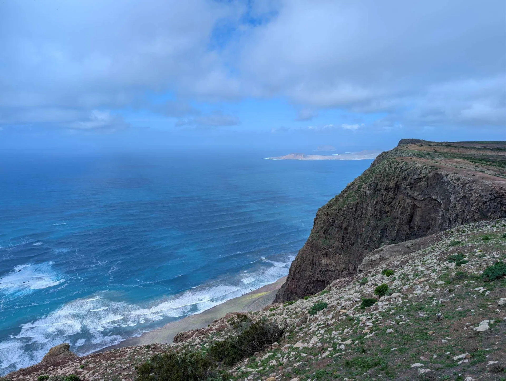
Famara cliffs
High above the sea: the Risco de Famara drops steeply to the turquoise water, La Graciosa on the horizon.
Once more the plunging view from the cliff edge to the turquoise sea.From the cliff edge, the view of La Graciosa's long beach.The wide sweep of Playa de Famara, far below the cliffs.Up on the plateau: a ruined wall among yellow flowers.The crest of the Famara cliffs, several hundred metres above the Atlantic.
A short walk to the spectacular edge of the Risco de Famara. Note: the access road is in very poor condition for the last stretch — not for low-slung cars or weak nerves.
San Juan beach — views of Famara
A small coastal settlement on the rocky shore, the Famara massif behind.
Rugged rocky shore with surf, the Famara massif behind.Through a volcanic valley full of winter green.A green valley running down towards Famara beach.Along a ridge with a wide view — the final kilometres.On the last walk of the trip, up over green slopes.
The last walk of the trip, with wide views of Famara and its long beach.
Clicking "Accept" enables Google Analytics (anonymised) for usage stats; without consent it isn't loaded. Personalised ads are handled separately through Google's own dialog.